
Disclaimer
What you are about to read is part 1 of a two-part series. Actually there is so much to write about, I didn’t want you to feel like you were reading a book, so I divided my exploration of “NorCal” into a northbound journey, and the return southbound journey. If you really enjoy this post, and you are thinking to yourself “I just gotta read the second part”, then check out the Northern California Coast – part 2.
Recovery
After about a week on the central coast, I spent a few days in San Francisco to rest and attend to some administrative functions. I had been moving to a new location every day for a while and luckily I was able to find a place to settle for longer than one day. From San Francisco, I finally crossed the iconic Golden Gate Bridge into Marin County, first by running/walking (there are so many people on the bridge that it’s difficult and dangerous to run the entire length), and then driving a few days later. No toll going northbound! I spent so much time around the bridge that I got pictures from all angles. Much of my time in the city was around the Presidio and Golden Gate Park. What city! What cool part of the world! There’s so much to see! Too bad a house costs you a million dollars to start, I would love to live around San Francisco. But before we move on, I have to discuss San Francisco a little.

Save me, San Francisco
That’s an ok song. San Francisco did help me out a lot. I was able to do laundry, charge my electronics, get on the web, and enjoy some good food all without having to hunt around for it like in Big Sur. Cities have their advantages.

Anyway, just like Monterey, I enjoyed the free spirit of San Francisco. I think the mild climate has a lot to do with it, but what’s wrong with using that to your advantage? I was able to catch up on the outside world (and blog post) from the Bazaar Cafe, which I found to encapsulate the spirit of the city. I particularly enjoyed the sign for their bathroom. That sign just about sums up the atmosphere at the Bazaar Cafe and much of the city. I wound up eating breakfast and lunch there while I was waiting for my laundry to finish. Thanks for the wifi!
I’ve been to San Francisco a couple of times before with my girlfriend (who used to live there). When I was with her, I got an excellent tour without having to worry about where to go and how to get around. Since I have seen a lot of the city already, I didn’t feel as compelled to “tour”, although I did visit a few of the popular places: Golden Gate Park, Ocean Beach, Fisherman’s Wharf, Lombard Street, and Twin Peaks. It’s a lot easier to hit all those places when you have 3 days and no real agenda. I don’t feel obligated to write too much about exploring San Francisco. It’s not difficult to find information about where to go in the city. However I will write about a big reason why I like this city so much: open space.
Cityscape
Golden Gate Park is apparently larger than New York City’s Central Park. I spent a better part of a day walking (I guess you can call it hiking) and driving around the park. There is a facility for just about every sport you can think of, even the obscure sports like Handball, Polo, and Lawn Bowling. Fun fact: The San Francisco Lawn Bowling Club is proudly the oldest municipal Lawn Bowling club in the country; started in 1901.
Golden Gate Park is well-known. It’s difficult to miss it on the map. I also visited some less traversed parks including Lands End Lookout (the very northwest corner of the city). I was surprised driving up the Great Highway. As you reach the northern end of the road, it turns east and into Point Lobos Avenue and there is not much traffic. Most of the traffic (if it reaches this point) continues down Point Lobos, but there is a huge area to the north with excellent views of the rocky cliffs, shipwrecks, and again, the Golden Gate Bridge. Lands End is another entry-free area run by the National Park Service, and it’s a great area to “outdoor explore” San Francisco with less of a crowd. Lands End is part of the Golden Gate National Recreation Area (GGNRA) (which I would explore heavily in Marin County a few days later). I didn’t realize how extensive the park’s boundaries are. It actually extends from Marin County in the north and deep into San Mateo County in the south. The park (or recreation area, park is easier to say) encompasses several of the sites I had been exploring including the Presidio and Ocean Beach.
Some of the many photos of San Francisco
I know it’s just a bridge, but like I said, I saw it from every angle and I couldn’t stop taking pictures.


OK we get it Joe, you took a lot of pictures of the bridge!
Over the Golden Gate
After a good recharge in San Francisco, I finally departed the city to continue up the northern stretch of Route 1. I determined shortly after departing San Francisco that I have an affinity for the ocean. I guess I always knew that, but it is crystal clear now. Most of my favorite hikes have been along the ocean, and hiking around Marin County added to the lot.
In Marin County, I first explored the Golden Gate National Recreation Area (GGNRA) immediately after crossing the bridge. There are a lot of scenic drives and viewpoints (many of the Golden Gate Bridge), but the trail network is extensive and the beaches are pristine. The entire area is free to the public which is peculiar since it’s a big area and the maintenance is top notch.
My relaxation from the previous few days spilled over as I primarily toured around the beaches and opted to drive (instead of hike) to the top of Mount Tamalpais, the highest point in the area. The State and Federal lands are intertwined around coastal Marin County. As I wandered in a generally northward direction, I traversed back and forth between the Golden Gate National Recreation Area, Mount Tamalpais State Park, and Muir Woods National Monument (that’s a mouthful). I drove through Muir Woods but, since it was still the weekend, there was absolutely no parking available. They actually had signs up as soon as I entered the park stating that the parking lots were full, and you needed a reservation to park in the lot. When I got near Muir Woods, even the pull-offs (which you are not supposed to park on) were full to the point people were parking in ditches on the side of the road with no shoulder. I’m sure it’s nice, but not worth the hassle for now.
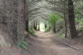
Time to find a less traversed area to explore! I tried Muir Beach (not exactly unknown, but significantly less crowded) which is only about 15 minutes from Muir Woods. You can have a fire on the beach! That’s unheard of on much of the east coast. I took a short hike to the top of the nearest overlook on the aptly named Coastal Trail. The Coast Trail follows the Marin coastline throughout most of the county and connects many of the trails in GGNRA and Point Reyes National Seashore. If it were clear, you could probably see San Francisco just few miles away, but the fog did not cooperate. There’s still a good view, but you can only see the immediate coastline. It was interesting to me as I explored the coastal areas of Marin County because a few miles inland there are redwoods everywhere, but the immediate coast is mostly grassy. I suppose this is because all of the “easy to get to trees” were harvested when they were building San Francisco, but maybe it’s a natural phenomenon. After an entire day traversing the 3 parks, I continued driving from Muir Beach along Route 1. Again, the coastal highway did not disappoint as I dropped into Stinson Beach. There were plenty of excellent views as the sky cleared up a little. The only thing I had trouble adjusting to was the fact that the fog concentration along the coast could change so rapidly as you move very short distances. Sometimes just going around a turn along Route 1 would clear up the visibility.


For all intents and purposes, I will consider the region north of San Francisco as the “North Coast”. I’m not sure if that’s the technical definition, but it makes it easier if I divide it up that way. Anyway, my first night along the North Coast was north of Bolinas about a mile off of Route 1. I found another overnight spot overlooking the ocean just like in Big Sur: quiet, secluded, and with a view. The only thing missing was some new friends, but there aren’t always people around when you find a place to overnight.

Point Reyes: an excellent day hike
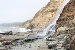
I departed my scenic overnight spot the next morning to hike at Point Reyes National Seashore. I had cell phone service (barely) the night before and I was able to research hiking spots around Point Reyes. At the southern end of the park (near my campsite) was the Palomarin Trail Head. The trail takes you a little over 4 miles along the coast, around a few lakes, and then to a coastal waterfall: Alamere Falls. About a half of a mile before the waterfall, I had to turn off of the main trail (not super evident) and crouch for a bit as I walked through a “tree tunnel” which led to the coast. There was something enchanting about this little section; like the forest was shielding me from the rest of the world above. I was super happy with my decision to hike to Alamere Falls even though it ate up a good chunk of the day. The weather was perfect and the views were excellent.
After my hike it was already 2pm! I thoroughly enjoyed Point Reyes and due to my inability to obtain a permit for the Lost Coast, I decided that I would return on my southbound journey to backpack around Point Reyes National Seashore. The only problem with this is that the park does not allow backcountry camping. I wouldn’t have known this during my hike as I saw what appeared to be several backcountry campsites around the trails. However there are 4 established campsites where you are allowed to camp for $20/night. I suppose that is acceptable.
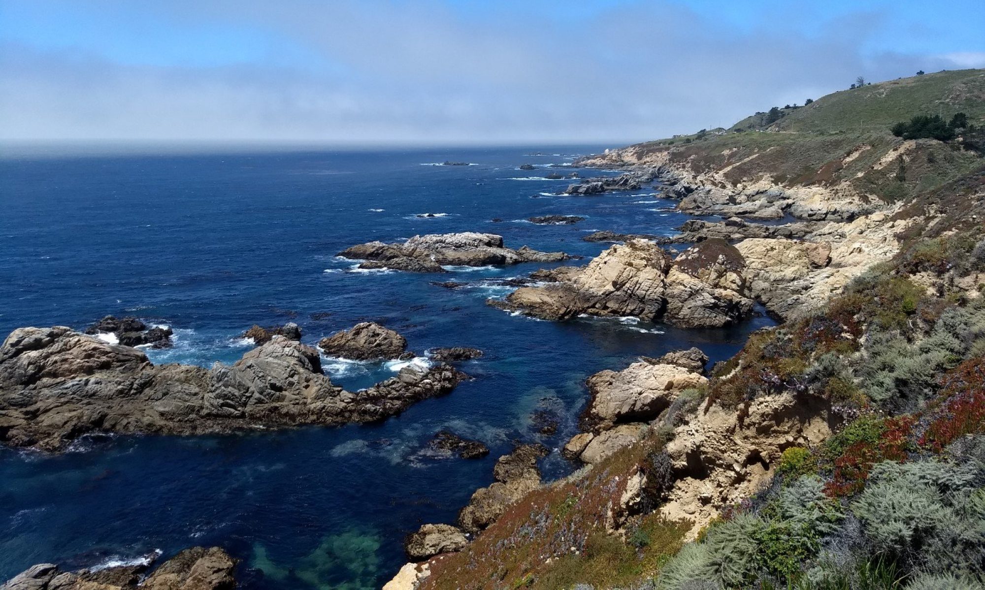
I got on the road, entered Sonoma County and ended up at a huge vista point/pull-off along Route 1 north of Jenner. The view rivaled the Big Sur overlook from the previous week. Not only was the view excellent, it was right next to the ocean! I arrived around 5pm and I wasn’t sure if I could stay overnight, but after sitting for a few hours soaking it in, the traffic died down and I decided to call it a day with no objections from the authorities.
How are we going to fit all of this…into that?
It was Tuesday morning, and I had made arrangements the previous night to purchase a used cargo hitch tray that I found on craigslist. Why did I need this? In approximately 10 days I would have 3 additional humans in my car and I didn’t have anywhere for them to sit. My car, including the backseat and front passenger seat were full of stuff! I would be picking up my girlfriend and her parents in Las Vegas and we would be touring through Nevada, Arizona, and Colorado over the course of a week. More on that later; but for now it was totally worth $30 for a used cargo tray (in brand new condition by the way) to provide more space inside the car for my passengers and their cargo. I called the hitch tray Sally’s backpack.

To retrieve Sally’s backpack, I had to drive inland to Hidden Valley Lake in Lake County, CA. I backtracked a bit to Jenner and continued east through Guerneville; a town that is almost engulfed in redwoods. Some of the trees were so close to the road, they looked like they would take my mirror off as I drove along Route 116. The temperature increased by over 20 degrees from Jenner to Windsor (about an hour drive).
My route also took me through Sonoma’s wine country which took the edge off of the heat (not tasting the wine, just the bucolic scenery). The Mayacamas Mountains basically separate Lake County from Napa and Sonoma Counties. From Calistoga, I took Route 29 which winds back and forth over the Mayacamas. This took almost an hour to drive in one direction and it was exhausting. After over 4 hours in the car and installation of the cargo tray, I decided to spend the night away from the coast for one night at Lake Sonoma.
Mendocino coast
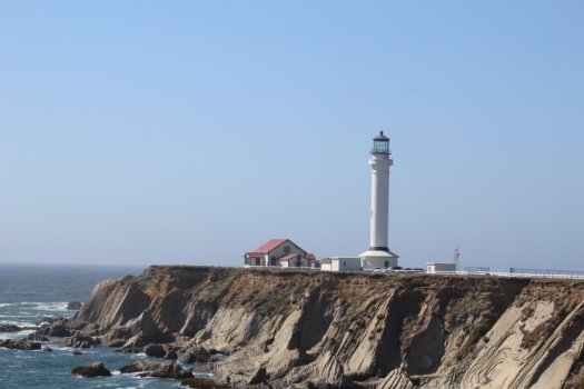
The following day I drove back toward the coast from Lake Sonoma. I ended up south of Gualala and spent a few hours unsuccessfully fishing and relaxing by the river. I then made it up to Point Arena to see the lighthouse and continued up the coast where I stayed the night right next to the ocean. The coast along Mendocino and Sonoma counties totally lived up to the hype for me. If you ask me to think of the coastal highway, Mendocino is precisely what comes to mind: picturesque, clean, rugged, sparsely populated, you name it.

I made one major pit stop in Mendocino County to re-supply and send some mail in the town of Mendocino. It amazed me that many of the little towns like Mendocino have managed to stay so small. A big reason (I think) why people like driving the coastal highway (besides the beautiful scenery) is because most of the businesses are locally owned. You won’t see too many Wal-Marts or chain stores in the tiny towns north of Marin County. I hope it stays this way.
Humboldt County and Redwood State Park
Humboldt?! That’s not a Spanish name. I realized while driving up the coast of California that all of the county names (at least along the coast) are of Spanish origin. Humboldt, however, doesn’t seem to match. Maybe someone can fill me in.
Before departing Mendocino County, Route 1 diverts inland as it traverses the King Range; a mountain range which proved too treacherous for the coastal highway to continue directly adjacent to the ocean. I wish I had a sports car for this final section. Route 1 winds up and down the mountains for about 30 miles almost entirely through redwood forests until finally terminating at US 101 in Leggett. From here you have a few options:
1) continue north on US 101 toward Redwood National Park
2) drive through a redwood tree (tourist trap)
3) turn south on 101 (or Route 1 for that matter)
I opted (unsurprisingly) for option 1. I tried option 2 first before realizing that it costs $10 to drive through a tree. I’m cheap. There’s not much utility in driving through a tree when you can see thousands of these giants (especially north of Leggett) for free! Shortly after starting along Route 101, you encounter the southern entrance for the Avenue of the Giants scenic drive which basically parallels Route 101. I decided to drive the entire stretch of the Avenue of the Giants starting shortly before Phillipsville.

After just a few miles, the Avenue of the Giants did not disappoint. Not only are some of the largest redwood trees in the world here, but they are literally lining the road. Who needs to drive through a tree when you can drive beneath thousands of them? Reminiscent of the trail to Alamere Falls, the trees provided complete shade from the sun and it felt like I was in a tunnel again, only this time on a much larger scale.
The Avenue of the Giants leads to Humboldt Redwoods State Park. When I was backpacking in Stanislaus National Forest, Noam lent me his map of Humboldt Redwoods State Park; I was honored. As I was driving along the Avenue of the Giants, the map came in handy as I didn’t realize I had already made it to the park this early in the day. I was looking for a place to fish by the river (running alongside the road) and enjoy the trees.


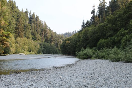
I decided to check out the Gould Bar near the town of Weott. The Gould Bar is a rocky beach along the South Fork Eel River. To drive onto the rocks, I had to take a steep dirt road downhill. This may have been the first time I got to truely test out the “X-mode” in my Subaru. I was so proud of my car making it down (and back out) of the beach without even skidding. Later in the day I helped two cars dig out of the rocks on the beach and make it up the hill. You should probably have four wheel drive if you plan to drive onto the Gould Bar.
For the rest of the day I fished (unsuccessfully again) and relaxed by the river. The river is so shallow that I could put my chair in and sit without being swept away. The only thing missing was a beer in the cupholder. What an awesome place to be (at least this time of the year).

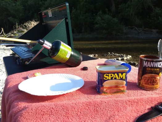
Making lemonade out of lemons – missing out on modern conveniences
Several weeks ago, I purchased a can of sloppy joe mix. I didn’t realize that the can is only the sauce, and the meat is not included. The can says “just add 1 pound of pulled pork, chicken, or beef” – fresh out. Since I lack refrigeration, it has been difficult to get cold food items that must remain refrigerated. If I purchase any dairy or raw meat, I need to use it within a day or two (I have a small cooler, but then I need to have ice ready).
Since I was in the middle of the redwoods at the Gould Bar with no ice or fresh meat, I decided to finally rid myself of this sloppy joe mix by making a substitution for the meat: spam! I am not sure if I have ever purchased spam before this trip, but it’s convenient to have since it doesn’t need to be refrigerated and it can double as fishing bait. I had opened the spam can earlier in the day for precisely that reason: bait. Of course you don’t need much, so I was left with an open, 99% full spam can. I didn’t forsee using the sloppy joe mix anytime soon since it had sat in my car for almost 3 weeks so I wound up with spammy-joe sandwiches for dinner. Maybe I was really hungry, but I recommend giving it a taste.
The next day I explored the rest of the Avenue of the Giants. It’s one of the best drives in the world as far as I am concerned. There are so many places to pull over and go for a hike or just admire the trees near the road. Several of the larger groves are named, especially at the northern end, primarily after wealthy sponsors. For example: the Rockefeller Grove has the largest trees in the forest.
I stayed on US 101 through the coastal towns. My car rolled over 50,000 miles at Fortuna (poor car, only 2 years old). I then made it to Eureka where the landscape looks more like the east coast with marshy areas and less mountains nearby (although maybe the fog was blocking them). By 9am I was in Redwood National Park. I had no idea there was no entry fee! US 101 winds through the National Park and the California Redwood State Parks and there is no cost just to drive through and hike.
Redwood National Park

I stopped at the Thomas H. Kuchel visitor center in Orick for my souvenir map and to figure out where to hike for the day. The Park Service ranger (I think his name was Rick) was super helpful and pointed out a few places for me to check out. I told him I was interested in a day hike and he circled about a dozen locations along the Drury Scenic Parkway. The parkway is much like the Avenue of the Giants in that it parallels the main highway, but puts you in the redwood groves. He also said for a good hike to start near the visitor center, there is the Lady Bird Johnson Grove Trail just a few miles away. I decided to follow his recommendations and check it out before heading farther north. Since I got to the park fairly early, the trees at the Lady Bird Johnson Grove were filtering sunlight from the fog. I had never seen anything like it. It was like the forest was alive and putting on a show for the early-morning hikers. I took about an hour to walk around the trail loop. Over the past few weeks, I had already walked through some impressive Sequoia and Redwood groves, but I don’t think they could get old. When I returned to the parking lot, the fog had cleared and I felt bad that the people just arriving to the grove had no idea what they missed just an hour earlier.
I departed the Lady Bird Grove and headed farther north on Route 101. I made several stops and stopped for a few minutes at the Elk Meadow and Prairie Creek (located within the state park) to see if I could spot any elk; no luck. Much like the Golden Gate Recreation Area, federal and state lands are intertwined here, so I was moving back and forth all day between them. I eventually made my way up to Klamath and decided to make it my northern limit for the coastal drive. Driving over the Klamath River put me into Del Norte County, so I could say I made it to every county along the northern California coast. I drove around Klamath for a minute, but to my surprise, there wasn’t much going on.
I then started southbound and went back over the river to check out the Coastal Drive near the mouth of the Klamath River. The air was intensely foggy along the Klamath. I went for a short hike where I finally encountered my first banana slug. I wouldn’t have even noticed it, but a father and son on the trail asked me if I had ever seen one and the boy ran over to some brush and pointed two of them out to me.


I returned to the southern end of the park to hike along the Redwood Creek Trail. I obtained a free permit to camp along the trail, as I thought it would be a very unique experience to camp in the park. I was hesitating to stay though, as I knew it would force me to drive more miles in the coming days. I decided I would scope out the trail first without all of my gear to see if it was worth sacrificing a day of driving.
As I started down the trail, another hiker started hiking right behind me and asked me a question (I can’t remember exactly what it was). I saw him at the trailhead as we were both checking out the map. I told him of my journey along the coast and across the country and that I was considering camping out along the trail. I found out that my new hiking companion, Eugene, was from the east coast as well; Philadelphia to be exact. He had just driven the coastal highway from Los Angeles in two days! He only had a few days in between workdays so he decided to take a long weekend and drive up and back. He told me he basically drove all day for 2 days. Yikes! He didn’t even seem tired. We wound up hiking together for almost 5 miles in one direction. Eugene and I wound up talking throughout hike. Even though I had just met him, it was like we had known each other for a long time. It’s great when you can connect with people when you are exploring the outdoors. I think it’s because you already know you have a common interest in hiking, and you go from there.
Anyway, I intended on going about 2 miles on the trail as you have to hike at least 1.5 miles to camp along the river. By the time we got back to the parking lot, it was 6pm and we had hiked 10 miles roundtrip. I thought it was a little late to be packing up my gear and hiking back into the woods to camp. So unfortunately, I decided to abondon my plans to camp out in the redwoods and start my trip south. I exchanged numbers with Eugene and we would try to catch each other later on as he would be driving south the next day too.

South
What goes up, must come down. It was sad having to leave Redwood National Park so soon, but I was able to see a lot in just one day. The entire journey up the northern coast was incredible and I would love to go back and really take my time to be able to see more. To see the journey south: check out part 2 of the Northern California Coast exploration.
Great post!!!! Sounds amazing. Ok, I have a few typos for ya: 1. Point Reyes – About a half a mile before I ?? the waterfall – something is amiss here. 2. Avenue of the Giants – To drive onto the rocks, I had to take a steep “dirt” downhill – I’m thinking “drive”.
anyway, great post. I can’t wait to talk with you about it. Luv ya. CL
Great post and beautiful pictures! Looking forward to reading part 2.
Thanks for reading! There was so much to write about it was hard to pick what to include