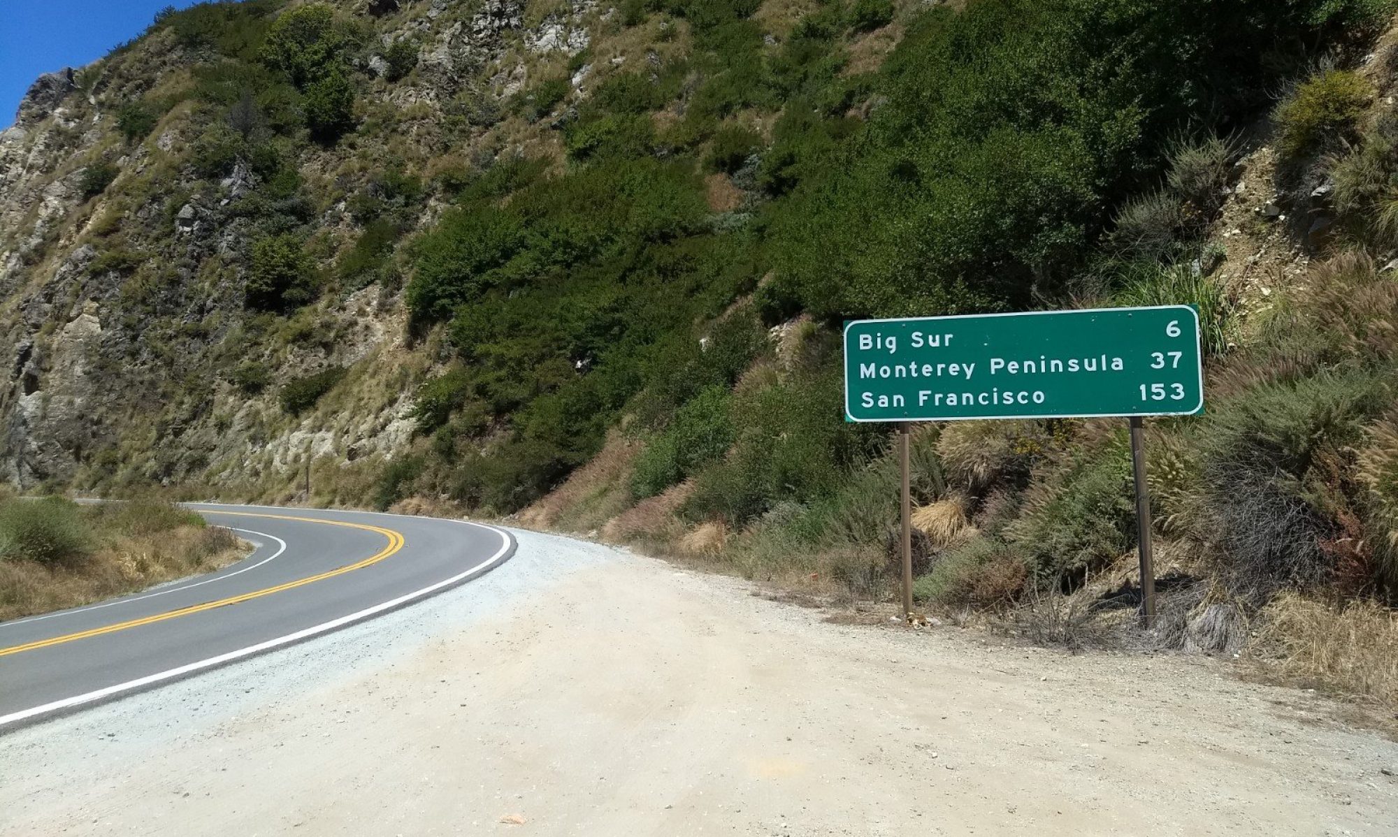

After almost 3 weeks along the California coast, it was finally time to drive to Vegas. It was a Tuesday and I had to be there Friday morning. No problem! What is on the way to Vegas? Well, Yosemite National Park is on the way (if you take a slightly longer route). Even though I had already visited Yosemite a few weeks earlier, it’s definitely a park where you need to spend more than 1 day. Also I wanted to summit Half Dome; something I was unable to do during my first visit as I did not have a permit (and I didn’t have enough time).
For some reason, San Francisco traffic starts very early in the afternoon. Apparently, the rule is: leave the city by 2pm to avoid traffic. Well, I left the city around 3pm, so I caught traffic in the city, Oakland and the entire east bay along interstate 580. The traffic didn’t stop as I continued east. There was apparently an accident (or two) that caused a slowdown all the way to Altamont Pass. By the time I arrived in Yosemite, my original 4 hour drive became a 6 hour drive. I was able to camp out at a point outside the park just before dark. At least I would have a full day in the park the next day!
Yosemite – a park so nice, he went there twice
The next morning I arrived at the Big Oak Flat entrance at 8am. I asked the park employee at the gate where I could get a permit to summit Half Dome. He said he wasn’t sure and I could check with the Information Station just past the gate. At the Information Station, there was a sign that stated that permits would be issued at the Visitor Centers (one of which was located in the Yosemite valley). Perfect! I was headed to the valley to get to the trailhead, so I could stop there first to obtain the permit.
I was starting to feel like I should have prepared better by researching the requirements for Half Dome. However, ordinarily if you are just going for a day hike, you don’t need to fill out any paperwork so this one snuck under the radar for me. For special hikes like Half Dome, you need a permit. My thought process was that the permits are issued every day, and if I got there early, I would be likely to receive one. I found out later that this is not the case. Am I to blame? The park service? A little of both?
Preparation – I think I finally learned my lesson
If you have read some of my previous posts, there is a repeating theme of situations where I have not prepared properly. Well, here is another:
I arrived at the parking lot for the visitor center at about 9am. It takes about 45 minutes to drive from the entrance to the Valley Visitor Center so my 8am arrival time was already becoming less relevant. The parking lot for the visitor center is about a half-mile walk to the actual visitor center, and the entire area was very crowded. The visitor center was packed. There were three long lines to talk to a park employee at the desk. I waited for 15 minutes and my line hardly moved. I was getting frustrated as it was already 9:30 at this point and I knew the hike was about 15 miles.
Next to the visitor center was the wilderness center where I assumed they issued wilderness permits. I wasn’t sure if the permit to summit Half Dome was considered a wilderness permit, but the wilderness center seemed significantly less busy (and I wasn’t getting anywhere at the visitor center). As I reached out my hand to open the door to the wilderness center, I saw a sign on the door that said “permits for Half Dome are not issued here, they are only reservable on recreation.gov”.
Alright, luckily I have a smartphone and I can get online to see if any permits are available. I found a spot in the park where cell service was good, and I checked out recreation.gov for the permit. I searched for “Half Dome” – 462 results. What!?!? I filtered by permits – only 6 results. I clicked on the result that made the most sense, and then the page refused to load. At this point my somewhat early arrival to the park was a lost cause as it was now 10am, and I wasn’t even at the trailhead. I decided that rather than waiting on the technology, I would simply make my way to the trailhead and ask (a hopefully available) park employee if there was anything I could do.
After I hiked up to the John Muir Trail, I finally found a park volunteer that could answer my elusive permit question. He stated that I needed a permit to summit Half Dome (I knew that already) but if someone didn’t use their permit for the day, I could claim the unused permit. I couldn’t know if there were any unused permits until I had made it to the base of Half Dome after hiking over 7 miles. I later found out that the permits are actually issued in a lottery 6 months in advance. With this in mind, my best (and only) option was to hike to the base of Half Dome, and try my luck to see if any permits were going unused. What a hassle. I guess it’s my fault for not knowing the rules, but I felt like the Park Service gave me the runaround. In their defense, Yosemite is very busy in the summer and there was probably something in the guidebook I received at the entry gate about how to get a permit. At this point it was noon and I had about 5 miles to get to the base of Half Dome.
The hike to Half Dome
I decided to take the Mist Trail to Nevada Fall instead of the John Muir Trail which I took on my previous hike to Nevada Fall. I thought the Mist Trail would be easier, but since it is shorter and more direct, it’s actually steeper and more crowded. The Mist Trail takes you near the bottom of the waterfalls and sprays you with a refreshing mist as you hike. I think the Mist Trail is faster, but the crowds slowed me down for a few sections.


I made it to my previous hike’s stopping point at Nevada Fall before 1pm. The next mile is relatively flat as the trail follows the Merced River. The trail then takes a left turn to climb the mountain to Half Dome. It was shortly after this that I realized I was almost out of water, and the sign at the trail junction said that there was nowhere to get water before reaching Half Dome. There is a sign early in the hike that says you should carry 4 liters of water if you are hiking to Half Dome. I definitely didn’t have that much, but I could refill on the descent. There were some streams off of the trail if I really needed it (I had a water filter). But after my hike, I recommend following the advice of the Park Service and carrying (or at least drinking) 4 liters of water if you plan to hike to Half Dome.

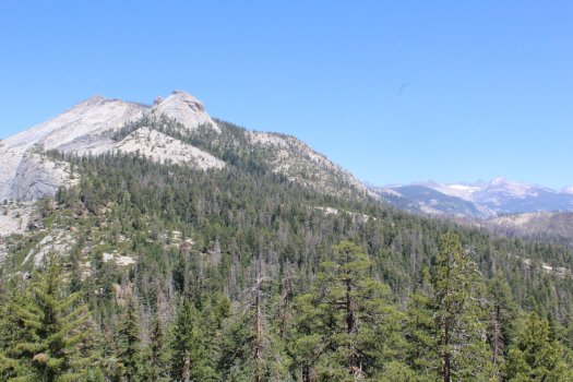
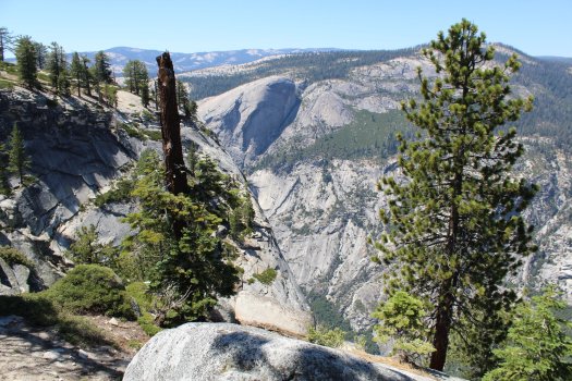
Other than marching uphill, there wasn’t too much unique about the stretch of trail from the Merced River to the base of Half Dome. Very scenic, but if you took a picture, you probably couldn’t distinguish it from anywhere else in the park. After about 4 hours, I finally made it to where I could see Half Dome. I didn’t even realize that you can see it from the valley, but the view from the top of the mountain is so much better. In addition, you get a spectacular view of the surrounding peaks. Unfortunately I did not get lucky enough to get a spare permit to get to the summit so I stopped near the dome. It was interesting watching the people make their way up the granite, as I could hear them very easily, but I could barely see them. I didn’t realize that there are cables to hold on to while you are making your way up Half Dome. I was wondering why so many people were wearing gloves (and why it was so “easy” for so many people to make it up the steep granite).
Half Dome
![Top [half] of Half Dome - Yosemite National Park - 7-31-2019](https://i0.wp.com/exploresinc.com/wp-content/uploads/2019/08/img_86141285114159318298897.jpg?resize=525%2C350&ssl=1)
Top [half] of Half Dome 
Hikers and cables near the top 
The tippy-top 
Half Dome – in case you didn’t know
I heard from a fellow hiker on my descent that there were two lucky guys that got a spare permit from the ranger at the base of Half Dome earlier in the day. It was almost 3pm, and I had heard that it takes at least an hour to make it to the top. Add 4 hours to hike back down and it would be dark before I got back to the car if there was another spare permit. I was satisfied making it to my highpoint on the trail. Now that I know the rules, I’ll make sure I enter the lottery months in advance to ensure I can summit Half Dome on the next visit to Yosemite. Three times is a charm.
Other views near the summit – Lots of granite


By the time I got back to my car it was almost 6pm. I hunted around for a shower but, to my surprise, there are no showers at the campground in Yosemite. I asked one camper if there was a shower and he said “it’s called the river”. I had to get on the road as I had a 2 hour drive to get out of the park and make it to a hot spring that I found to stay for the night south of Mono Lake. I hadn’t seen the eastern part of Yosemite, and as I made my way toward Tioga Pass, I realized what I missed by not exploring this part of the park. It is much less crowded, there are clear lakes everywhere, and the landscape changes between meadows (especially the large Tuolumne Meadows), forests, and granite.
I’m seeing stars
My timing worked out, as I made it to my overnight destination with just enough sunlight to set up. The eastern side of the Sierra Nevada has some of the darkest night skies in the country, so I was lucky I didn’t have to break out the headlamp to set up. With the dark sky at night, the stars did not disappoint.
I’m not an astonomer, but shortly after I sat down to stare at the stars, a huge meteor/asteroid/shooting star (pick a term) streaked across the sky. Not a typical streak that looks like a plane flying super-fast and high in the sky; it was more like a wide yellow beam at a much lower altitude (but just as fast). Imagine the Star Wars opening credits in fast forward. I wish I caught it on camera. Maybe I spotted a UFO. It was headed toward Nevada after all.
Update: after talking with some astronomy buffs, I determined that what I saw in the sky was a “fireball”, a type of bright meteorite or bolide that is very low in the atmosphere.

You can’t always get what you want
The next morning I woke up to check out the nearby hot spring. I didn’t see the hot spring where it should be based on the map, so I walked by a couple in a camper-van and asked if they knew where the hot spring was located. They pointed and said it was “over there” but told me it was dry. D’oh! Just my luck. I eventually found the hot spring, and it had enough water in it to get my feet wet. It was just water that had come out of the hot spring recently, so I burned my feet a little. Nothing like burning your feet in the desert to start the day! There was another hot spring with water, but it was packed with people by the time I got there. It appeared that it is well known by the locals. So I missed out on my hot spring, time to get on the road. I had to be in Las Vegas the next day.
A second chance at the Bristlecones
I passed through the major settlements along US 395: Bishop, Big Pine, and Lone Pine. In Big Pine, I saw a sign for the “Ancient Bristlecone Pine Forest“. It was a 20 mile detour up a mountain, but since I missed out on my opportunity to see the Bristlecones a month earlier at Great Basin National Park, I decided I would take this opportunity to check them out.

After a 45 minute detour up windy roads, I stopped at the park entrance at an elevation of around 10,000 feet. There are two trails you can take: the Discovery Trail (a 1 mile loop), or a 5 mile loop. I was just making a quick stop so I opted for the 1 mile loop. Most of the trees in the grove looked dead (and maybe they were), but it was very cool walking by these trees that live to be thousands of years old and only grow under very specific conditions. The form of the trees is very unique as the trunks and branches are twisted over time. If you are not very interested in trees, the mountain views from the Bristlecone forest are some of the best I saw of the Sierra Nevada. It’s definitely worth a stop if you are driving through Big Pine.

After the Bristlecone detour, I returned to Route 395 and headed south to Lone Pine. At Lone Pine I got to see Mount Whitney (the highest point in the lower 48 states) and I turned west on Route 136 toward Death Valley (with the lowest point in the US). It’s interesting that these two points are just a couple of hours away from each other.

Heading East toward Death Valley, not much to see for the next 100 miles 
Looking back West – the Sierra Nevada, I think that’s Mount Whitney
Death Valley – just as inhospitable as it sounds
Death Valley might be a cool (no pun intended) place to visit in the winter, but driving through it on August 1st: not a good idea. I wanted to check out Death Valley and I was willing to take on the heat, but at 120F, I didn’t get out of the car for very long.
Some highlights from Death Valley:
1) Heat
2) Steep grades
3) Joshua Trees (where they can survive)
The landscape is interesting, but Summer’s heat is a big deterrent to doing much, especially hiking. I just wanted to drive through and get below sea level. It takes about 2 hours to drive from Lone Pine, through Death valley, and to the Nevada border; and the elevations range from over 4,000 feet above sea level to less than 200 feet below sea level. At no point was the temperature less than 112F and there was, unsurprisingly, no chance of rain.
At the aptly named Furnace Creek, I got to one of the lowest elevations, and hottest spots, you can drive to; at 190 feet below sea level. It was 120F at the visitor center, the highest temperature I saw. The lowest point in the US, Badwater Basin, is 282 feet below sea level, but after driving for about an hour through the park, I didn’t make the extra hour-long detour to the absolute lowest point. There isn’t much to see, plus I didn’t want to cook myself anymore than I had to.
Death Valley – the definition of arid


Desert heat
Exiting Death Valley to the east, I ended up at Death Valley Junction, where I made a quick right-and-then-left turn onto State Line Road entering Nevada. After a few dozen miles, I made it to Pahrump where I was greeted by cell service and a cool temperature of 100F. I stopped for some supplies at good ol’ Walmart. After that, it was just a 45 minute drive to Red Rock Canyon where I stayed for the night. From Red Rock, it’s only another 45 minutes to McCarran Airport, where I would make the rendezvous with my girlfriend in the morning.
When I made it to Red Rock, I started to unpack my tent and cooking equipment. I smelled a garlic-scented odor coming from the plastic bin on the cargo tray outside of my car. As I smelled around to detect the source of the odor, the garlic smell became mixed with a burning smell. That’s when I realized that the garlic smell was propane and the propane tanks for the coleman stove were inside of the bin. As I opened the bin I realized that the combination of the extreme desert heat, hot car exhaust, and a heat absorbant black-colored bin all caused one of the propane tanks (luckily only one, there were 4 in the bin) to overheat/over-pressurize and explode.
I’m not entirely sure of what happened since it probably happened in Death Valley a few hours earlier. Whatever happened, the bin was melted near the exhaust pipe along with many of the items in the bin near the exploded tank. I consider myself lucky since this could have started a car fire or something worse. After this, I’ll no longer be placing anything on the cargo tray near the exhaust, especially when driving in a hot climate. I’m also keeping the propane tanks inside of my car as it seems that the temperature inside the bin gets hotter than the inside of the car.
Casualties:
1) Husky 35L tote
2) 1 coleman propane tank
3) 1 insulated grocery bag
4) 1 sleeping pad

Melted bin 
Close up 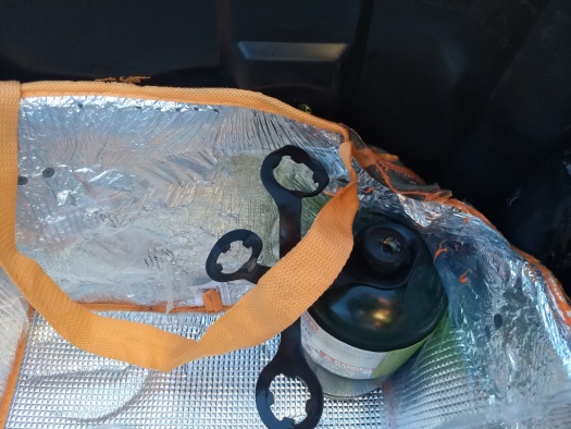
The warning on the tank says “do not expose to temperatures over 120F”
Administrative Tasks
The next morning I had to run a few errands to replace some of the melted equipment from the previous day (most importantly, the bin). After a stop at Home Depot, it was time to finally fetch my better half from the airport.

Next, we will be exploring the Las Vegas area briefly, and moving farther inland to the Grand Canyon and beyond with some much needed company. Thanks for reading!
Continued safe travels Joe. I have never been to California, but your blog has been more inspiring than a tour book! After a road trip to the National Parks in 2011, I wondered why anyone lived east of the Mississippi! I am sure you feel the same way.