

It seems likes everything is bigger in the Sierra Nevadas. The highest mountain in the lower 48 states is in the Sierras. I think the biggest waterfall in the US is in the Sierras. And the biggest trees (by volume) are in the Sierras. While we were wrapping up our hike in the Hoover Wilderness, I asked the guys if they knew of any place(s) to see nearby after our trip was complete. I think everyone I asked said “Big Trees” at one point. If you haven’t been to the Sierras, you would probably have the same reaction I did: “Big Trees? There are all sorts of big trees.” The Big Trees they spoke of is Big Trees State Park near Murphys, CA. It’s a beautiful park only about an hour or two from where we split off in Twain Harte.
I rode through the town of Sonora, the only place with good phone reception, and picked up some supplies from my new go-to store: Walmart. I also reconnected with the outside world. It was amazingly unstressful backpacking dozens of miles over the course of 5 days; where you have to gather firewood to stay warm at night, set up shelter, haul water up a hill to be able to cook. And yet when I returned to civilization, the text messages, emails, and phone calls started rolling in, and I felt like turning back into the woods (except I did want to get a shower first). Of course I did wind up going back into the woods because I was visiting Big Trees. There is a lot of history in the towns leading to Big Trees, especially regarding the gold rush and Mark Twain (e.g. the town of Twain Harte). According to the information center in Angels Camp, Mark Twain stayed in the town and it’s where he wrote his first book: The Celebrated Jumping Frog of Calaveras County. That explained abundance of frog peraphernalia at the many gift shops in town. I had no idea! As much as I like history, I was trying to make it to Big Trees before dinner, and it was already 5pm. Needless to say I didn’t have much time to explore the little towns of Angels Camp, Murphys, and Arnold, but if you are a fan of Mark Twain’s novels, the area is certainly a place to visit.
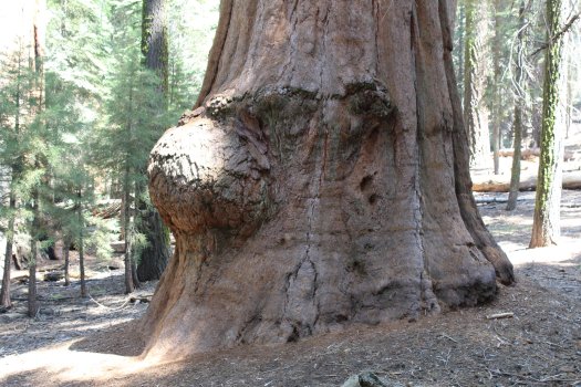
I got to Big Trees around 6pm and I stayed at the North Grove Campground (right next to the park entrance). The campground was fantastic. California maintains their state parks better than most, but that makes for a fairly high cost for entry/camping fees. $35 per night at Big Trees, but a campsite right next to the showers, plenty of firewood, and a nice level pad for my car/tent. I spoke with the people at the campsite next to me, and they had visited one of the Sequoia groves earlier in the day. They made it sound so magical. I kept looking around the campsite for what I thought was a Sequoia. There were plenty of big trees around, and I asked “is that one?” My neighbors were not tree experts so they replied, “I don’t think so”. I would later find out that the Sequoias are much fatter than what I was looking at; although the Sugar Pines and Cedars around the campsite were quite tall as well
Treemendous
Sorry, I had to write that awful pun. I woke up nice and early to visit the grove of Giant Sequoias around the North Grove (walking distance from my campsite). I had never seen a Sequoia before, let alone hundreds of them. There are two major Sequoia groves in Big Trees State Park: North Grove and South Grove (clever naming). Lenny mentioned that I could just spend an hour in the park to see the trees, but I spent almost 2 hours in the North Grove alone. When you first enter the North Grove there is a stump of an old Sequoia that was repurposed as a dance floor in the 1920s. There was no saw large enough at the time to cut the tree down, so the tree was drilled in order to get it to topple. Dozens of drill holes are visible on the felled tree, still present next to the stump.

Sequoia Dancefloor 
Drill holes in the rest of the tree
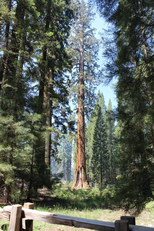
At the start of the North Grove Trail, you can opt to take the Grove Overlook Trail or the Grove Loop. The overlook trail takes you by a few large Sequoias, but the overlook was a little disappointing (probably due to the spectacular views I saw over the past few days backpacking). It was a very peaceful walk though. I didn’t see anyone going up or returning; just some squirrel friends. After returning from the overlook trail, I promptly went around the Sequoia loop trail. “That’s more like it!” I thought to myself. There is a Sequoia tree every few paces it seemed. The loop trail is super easy and it certainly highlights the bigger trees in the grove. Since the Sequoia cones/seeds need to be heated to germinate, the trees themselves are semi-fireproof, hence the dense wood. It was interesting to see most of the larger trees (only a thousand years old or so) with huge burn scars from previous fires. As I saw in Dardenelle, fires are part of the natural cycle in the Sierras, and the trees have evolved alongside the fires. It’s for this reason that the Forest Service has prescribed burns (as I would see later) in order to help the trees regrow “naturally”, and reduce the fuel on the ground in the event of a natural forest fire.
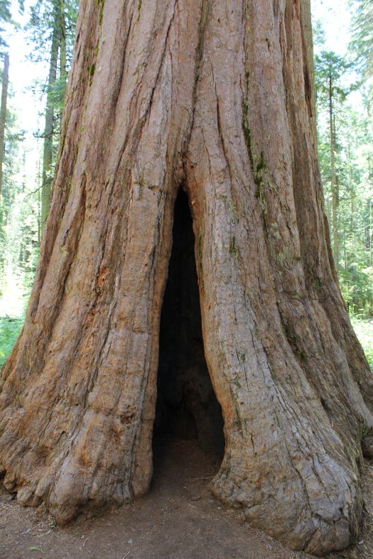
I felt compelled to check out the South Grove as well. It’s about a 15 minute drive to the trailhead for the South Grove. You cross the Stanislaus River, a good spot to stop and listen to the water rush by. The South Grove is more secluded and you need to walk about a mile down the trail to start seeing Sequoias. I didn’t make it all the way to the end of the loop, but one of the park employees told me on my way back to the parking lot that the biggest tree in the park are at the end of the loop. Of course they are! Oh well, I still saw plenty of massive Sequoias in both groves.
As I stated earlier, California parks are expensive. You see why in how well most of the parks are maintained. In Big Trees, I walked past at least a dozen employees or volunteers sweeping, raking, and pruning along the trail. I had never seen such diligent care of a state park before. I told a few of them that it was the cleanest trail I had ever seen. There was hardly a pineneedle on the trail. Very neat, but that level of maintenance makes the campsites pricey.
I was so excited to leave Big Trees only because I was headed toward Yosemite National Park; a place I have wanted to go for the longest time. I stopped again in Sonora for some souvenirs and to ship some unneeded luggage back east (thanks Mom and Dad).
It was about an hour to drive from Sonora to Yosemite. I was happy that I was finally in situation where I wasn’t pushing to drive 6 hours or more in a day and the next stop was just a relatively short drive away. The National Parks and Forests in the Sierras are so vast, there are so many places to set up camp for free (hard to find on the east coast). I think the Forest Service actually encourages camping outside the park so that the park/forest campgrounds aren’t overwhelmed. Yosemite was completely booked for campsites so I was able to stay off of a side road a few miles outside the park near the Big Oak Flat entrance. This was great: a river was next to the road, the site was flat, and very few cars drove by.
Yosemite – one day only
The next morning I got up early to try to beat the crowds at Yosemite. I definitely got there before it was too crowded, but in the Summer I don’t think the crowds ever really die down. A bit of advice when you reach the Yosemite Valley (where the crowds are): stay alert; especially if you are driving. Unfortunately with the crowded traffic in some locations, and the amazing scenery, some drivers decide to take their eyes off the road (and even try to take pictures) while driving. Lucikly there are a lot of pull offs so that you can get out of the car and look around just about anywhere in the valley.
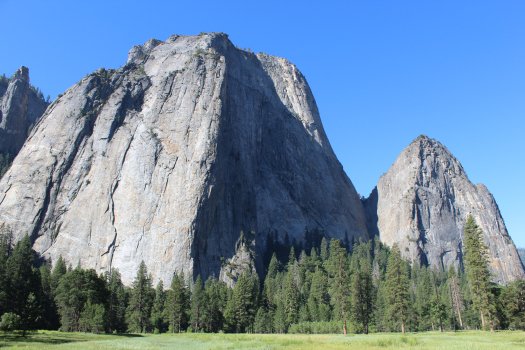
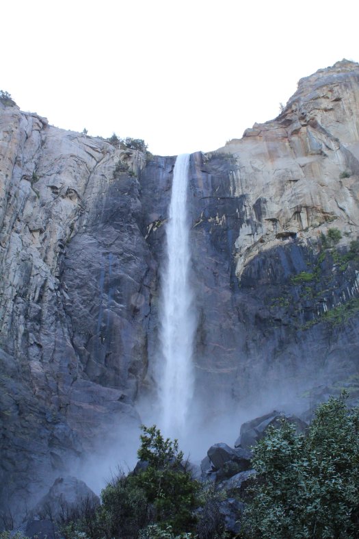
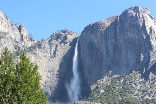
I stopped at Bridalveil Falls (a must stop and see) viewable from just about anywhere in the valley. I then continued around the valley loop taking pictures of the famous Yosemite Falls and El Capitan. The valley itself has so many treasures, you could spend a week just looking around. I eventually stopped sightseeing in the valley and settled on a stopping point for a hike.
Pictures from The Yosemite Valley


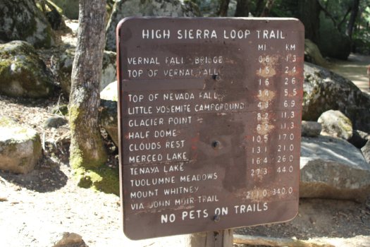
I decided that I would hike part of the John Muir Trail, one of the most famous trails in the world for my Yosemite hike. I had made camp reservations for the next night at Kings Canyon National Park, so I only had one day in Yosemite (mistake on my part). The northern terminus of the John Muir Trail is at the end of the road in the valley, near The Pines Campground. After finally finding a parking spot about a mile away, I started my hike. I planned to get to Nevada Fall (not Falls), which (with my added parking distance) would turn out to be about a 9 mile round-trip hike. I could have continued from Nevada Fall to Half Dome, but I just missed seeing it by about a half-mile. You need a permit to summit Half Dome, and it was an additional 4 miles to reach the summit (one-way). One day I will return prepared and hike to Half Dome, but it wasn’t a priority for me. Any hike in the valley is satisfying.
The ascent up the John Muir Trail is steep. It starts off paved until you get Vernal Falls. There is a water bottle fill station (use it!) and a bathroom. Once you continue from Vernal Falls, the trail becomes a trail; much more rugged and with plenty of switchbacks. This is about the time a significant amount of fairweather hikers dropped off; either from fatigue of climbing the steep hill to Vernal Falls or from inadequate clothing/footwear. I saw so many people hiking in basketball shoes, swimsuits, etc. You really need hiking shoes/boots to continue up the trail. It’s rocky and slippery.
Despite only going a few miles on the John Muir Trail, I’m convinced anywhere along that trail is an excellent hike. Especially in the Yosemite Valley, I couldn’t stop taking pictures and admiring the pristine condition of the area. With all the visitors to the valley each year, it’s amazing that the park stays in such good condition.
I made it to Nevada Fall in about 2 hours (with plenty of stops along the way). There is a bridge that takes you over the Merced River just a short distance from the edge of the waterfall. You can walk right up to the waterfall (the safer side with a guardrail is across the bridge). It would be extremely easy to fall over the edge, so watch your step if you go.

I was a little disappointed that I didn’t make it to Half Dome, but I only had one day and a few hours drive ahead of me. I was able to get back to my car in a little over an hour. Downhill is so much faster! I was reversing course of the furious uphill from earlier and I could see the stress on some of the hikers’ faces going uphill toward the waterfalls. When I was finished my hike, I found out that you can also take the Mist Trail as a shorter and less strenuous alternative to Nevada Fall.
Nevada Fall pictures
I would love to hike the whole thing, but I only have 1 day 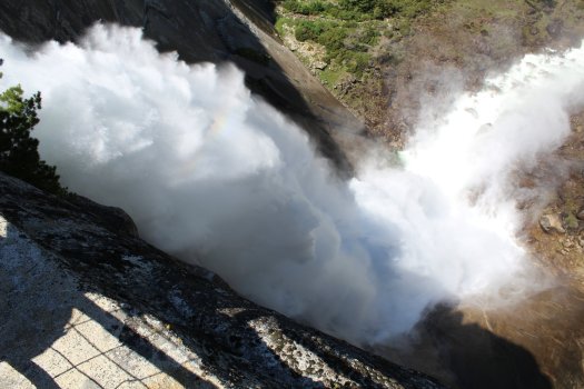
From the top of Nevada Fall 
Liberty Cap and Nevada Fall
More Sequoias – Kings Canyon and Sequoia National Park
I was out of Yosemite by 3pm. Again, I was sad that I couldn’t spend more time there. Once I got on the road, I realized that I had 3 hours to drive to get outside of Kings Canyon National Park. It was interesting driving out of the mountains into the central valley. The air was quite hazy so despite knowing there was a spectacular view behind me, I could just barely make out the mountains after driving only a few miles past the foothills.
For the second night in a row I camped just outside of a national park (for free!). This also allowed me to get very spotty cell phone coverage (a battle I realize I will have to fight continuously throughout my time in the National Parks). I was able to drive to the entrance of the park in less than 20 minutes in the morning and start down the Big Stump Trail.
Stumps you say?
The Big Stump Trail is a left turn just after entering the park from the west on route 180. It’s a great trail for the novice hiker and allowed me to ease right into the park. The Big Stump Trail is named for…stumps from old Sequoia trees that were chopped down back when it was the thing to do. There are dozens of them and it’s a little sad walking through. Trees that take hundreds of years to grow were harvested in days. Pioneers and early loggers in the Sierras saw the value in the hardy wood, and built cabins and sold hundreds of trees-worth of lumber in the 1800s. It is certainly durable wood, but Sequoias cannot regenerate nearly as quickly as they can be harvested, even with 1850s technology. This is part of the reason why the Sierras are so heavily protected. I forgot to report this to the Park Service, but I came across the cow in the forest. I’m assuming he escaped from a nearby pasture and he was on the lamb. I’m no snitch!

Stump Meadow, harvested over 100 years ago 
The Twain Stump 
The mysterious forest cow
A sign at one of the stumps (I think it was The Big Stump) was where Mark Twain would hike to when writing. Mr. Twain, Clemens really, certainly encountered some inspiring sights in his day. Imagine how raw the landscape was in the late 1800s! It would be amazing to stand in the forests with less stumps and an abundance of Sequoias before they were harvested.
OK you get it, there are a lot of stumps there!
I proceeded a few miles down the road to the Grant Grove. All of the larger trees in the park seemed to be named after famous Civil War generals. The Grant Grove features the General Grant Tree and his tree soldiers. While I was in the Grant Grove, they were felling some trees and I got to hear one monster crash onto the forest floor. I don’t think I could grow tired of being surrounded by these enormous trees. Every sequoia grove I saw on the map I wanted to see in person. I had already spent 4 hours in the park and it was only noon. I was able to check in to the campground at noon so I decided to call it an early day and relax at my campsite.
General Sherman? I thought that was a fish.
I’m sorry if you are not a fan of the Simpsons and you don’t get that reference. I departed my campsite the next morning fairly early as I had planned out the route for the day. I was going to drive through another large Sequoia grove and see the Sherman Tree, the largest tree on earth by volume. The Sherman Tree is actually located in Sequoia National Park, directly adjacent to Kings Canyon and Sequoia National Forest. When you pay to get into Kings Canyon, you get into Sequoia since they are basically one big park. I have the annual national parks pass so I could stay for an entire year if I wanted to!
The Sherman Tree is unbelievable: 36 feet in diameter, over 2,000 years old, 275 feet tall, and survivor of potentially hundreds of fires. What a relic! Sherman is surrounded by his soldiers as well. Dozens of equally impressive trees dot the forest. As I drove toward the exit of the park, just south of the Sherman Tree, is the Giant Forest which contains a Sequoia grove with the largest specimens in the world. I have a suspicion that there are trees even larger than General Sherman, the Park Service just doesn’t inform the public. At one point the road splits the lanes in order to squeeze past a few of the giant trees. I wish I was the passenger so I could have a better look. I highly recommend driving on Route 198 through the Giant Forest. I felt like I was in Jurassic Park or something. Around the Sherman Tree and the Giant Forest, the Forest Service was conducting a prescribed burn which made the air very hazy. I feel bad for the people that live in the central valley as they have some of the worst air quality in the country, and I’m sure the smoke from the fires is a contributor.


After some deliberation, I decided to power through and drive all the way to the California coast; about 3 hours of driving from the foothills through some amazingly productive agricultural land, pastures, vineyards, and coastal mountains. Route 198 takes you through citrus and olive groves, tons of vegetable farms, and I believe almond groves until you hit the city of Visalia. From there until you hit the coastal mountains the climate becomes even more arid and the hills turn golden composed of dry grasses for cattle grazing. I had to slow down shortly after getting on route 46 as a wildfire had broken out on one of the farms right next to the highway. It’s dry in the southern central valley. As you make your way west into San Luis Obispo County (SLO), the humidy starts to increase and you can see the sprawling vineyard estates that surround the hills. Once you get over the mountains, you can see the ocean and marine layer (fog) from about 2,000 feet up on top of the rugged coast range. I eventually got to CA Route 1 and turned north.
I was headed toward the central coast and Big Sur, another place I have wanted to visit for a long time.
Your blog is great! I’m enjoying your adventures!
I’m going to try. It’s still a long drive but I think I’ll make it!
Joe, I am enjoying your blog immensely. Are you going to see the Avenue of the Giants to see the Redwoods?
James