

After driving out of Sequoia National Park and through the Central Valley, I stopped in Paso Robles to get an early dinner at Jack in the Box and inquire about campground availability near the coast. The answer: there wasn’t any. I called the San Simeon Creek Campground which would be the first one I passed once I got to Route 1, and they said they didn’t have anything available. I then talked with an employee at the Morro Bay location and he said “sorry we don’t have anything from here to Santa Barbara, the entire coast is booked”. It was Friday, it was the weekend in July, but I thought there would be something open!
Luckily I had my magical smart phone and, at the time, phone service so I was able to look up some free locations online. I found one north of San Simeon that looked semi-promising. Supposedly there were up to 5 primitive campgrounds along a gravel road just off of Route 1. That was good enough for me. I drove for about 30 minutes from Paso Robles to Route 1. The temperature dropped dramatically. It was over 100 degrees in Paso Robles. Now along the coast, it was 60F and it continued to drop as the fog thickened. After stopping for a minute to look at the Elephant Seal “Vista Point”, I drove until I arrived at the entrance of the gravel road.
The best things are free
It turns out that the gravel road leads into Los Padres National Forest, specifically the Silver Peak Wilderness which straddles the coast once you cross into Monterey County. After driving only a few hundred feet up the gravel road, there is a sign that says “Road impassable in wet weather”. Well, I hope it doesn’t rain! I had yet to experience rain since I arrived in California almost 2 weeks earlier. The road became very steep and there were some pull-offs every 100 yards or so. I saw a few camper vans and cars with tents parked in some of the pull-offs. One of them had snagged a spot with a view of the ocean. I decided that I would continue up the hill until I could find another spot with a view. The road was so steep, I assumed there would be another spot with a view.
I drove very slowly as there is no guardrail and the road is curvy and rough. It was a long 2 miles, but I eventually turned a corner and arrived at a viewpoint that a few other folks had already beat me to. But it was big! There was enough room for about 10 cars and I decided to park there for a minute to check it out. After climbing up the hill to an elevation of about 1,000 feet, the temperature had risen about 20 degrees since I had climbed above the marine layer to a pleasant 80 degrees. I didn’t know if the people at the viewpoint were locals or travelers. It turns out it was a little of both. The gravel road continues up the hill and there are apparently houses where the locals live, but I wasn’t adventurous enough to find out how far up this road you have to go to find civilization. You need a truck if you are going to live up there!

Before I ever visited California, this location was what I thought of when I thought of California: amazing scenery, sunsets, friendly people, and you can just camp out along the coast (as long as you keeping it clean and you aren’t causing anyone any trouble). Upon exiting my car, I was immediately greeted by the folks at the viewpoint. I met Katie first, who came over to say hello before I could even close my car door, and she introduced me to everyone a few moments later. Katie was traveling with Andrew, from Texas, for the weekend. They were both into skydiving (something I have yet to do) and I later found out they had each done hundreds of jumps! Andrew had a camper van that he had customized inside. It was pretty big, and impressive. He had been on the road for 6 months traveling around the country. There were also a few locals who had been talking with Katie and Andrew. They had some interesting stories that they didn’t seem mind sharing with strangers. I assume the locals see people passing through all the time and they enjoy chatting with them. I also assume they are pretty isolated living up the hill so they are happy to chat with most people that stop by. This made for a great atmosphere to end a pretty long and stressful day of driving and campsite hunting. A couple of hours ago, I wasn’t sure if I could find a place to stay for the night. Now I was enjoying an incredible sunset with some new friends at an amazing location, for FREE! I don’t want to give away any more information about this place because I want to keep it semi-secret, but I think I left enough clues if you want to find it.
Anyway, about an hour after I arrived at the viewpoint, we were joined by a few more folks at “the point”: a couple from Florida, who had also driven a custom camper van across the country and another couple (Buddy and Meghan) from Seattle. Buddy and Meghan had setup camp earlier down the gravel road and then drove their car up the hill to see the view. After checking it out, they quickly decided to retrieve their stuff from down the hill and reset camp at the viewpoint with the rest of us. It was too good of a spot to not stay once you know about it. We all watched the sun set and it was particularly good. I took so many pictures of the sunset and I was experimenting with the camera settings so I couldn’t pick the best sunset picture. Either way, I don’t think a picture can top seeing a California sunset in person, but I tried:

About 10 minutes to go 
closer… 
20 seconds? 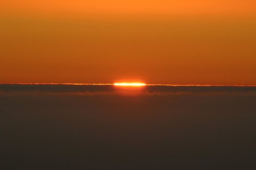
See ya tomorrow!
It started getting cold shortly after the sun went down. I was hoping that since I was out of the big mountains it might be a little warmer at night, but not really. I fell asleep with a great view of the stars and a somehow relaxing sound of seal barks echoing up from the ocean.
I see why the California coast has a reputation for being so relaxed. The next morning I woke up, but I didn’t get out of bed for almost 2 hours. It was getting light outside but since the sun has to rise over the coastal mountains, the sun doesn’t actually come out until much later. It’s like nature’s snooze on the alarm clock. I totally felt like I was on “island time” or “California time”: not in a hurry to go anywhere. And why would I? This was one of the coolest places I’ve seen on this trip.

I wasn’t used to the “marine layer” either, so it was interesting watching the fog move up and down the valley in the morning. It’s just another reason why this location was so magical: the marine layer could never quite make it up to the point.
I said goodbye to my viewpoint friends as everyone was getting on the road around 9. I needed to get my hike in for the day so I took a short hike down to the nearby creek, but there wasn’t much to see. After I returned to the viewpoint, everyone had left and I made my descent back to Route 1.
Conservation is awesome!
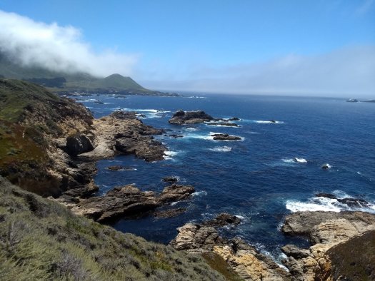
I decided I would venture south first and head back toward some of the sites I had driven past the previous day in my haste to find a campsite. The stretch of highway from San Simeon to Gorda is amazingly scenic, and a little treacherous. The speed limit is 35 miles per hour as the highway moves along the cliffs. You need to slow down significantly to make some of the turns. Route 1 generally hugs the coast throughout Big Sur; so there’s no shortage of scenery.
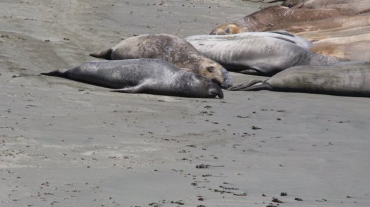
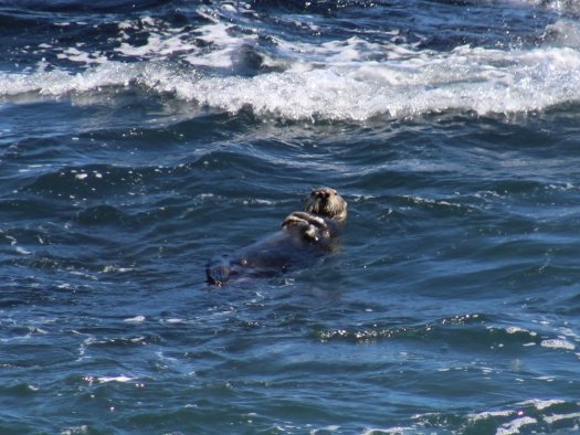
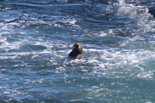
Seals and Otters
I returned to the Elephant Seal Vista Point before turning back north. I’m not particularly interested in the seals, but the “Friends of the Elephant Seal” organization certainly helped me learn all about them. I just wanted some pictures, but the signs all around the viewing “boardwalk” help you learn all about Elephant Seals. There are hundreds of them lying on the beach. For the most part, there isn’t much action until one of the big males decides to pick a fight with another male. That’s what most of the visitors are waiting for; reminds me of some humans. Warning: the seals smell if you get close, but how often do you get to see something like this?
The Vista Point is right next to Piedras Blancas (en ingles: White Rocks) that stick high out of the ocean near the shore. It was here I also got to see a sea otter playing in the surf. Much of the central coast is a marine reserve which allows for the opportunity to see some pretty rare and/or endangered animals. I didn’t see any whales, but I hear they are commonly sighted.


I turned back north and stopped at Salmon Creek Falls, which appeared to be popular based on the number of cars parked at the trailhead. I was up for a short hike, and luckily this trail can turn into about a quarter-mile hike just to reach the waterfall and swimming hole (an added bonus). Talk about a gift of nature: Salmon Creek Falls has a ~50 foot waterfall, swimming hole, fishing opportunities all within a short walk. I spent most of the afternoon here as it was peaceful and scenic. I swam for just a few minutes at a time as the water is much colder than I am used to, but I had to swim since I was there. Definitely take a short hike at Salmon Creek to the waterfall if you ever drive by on Route 1.

Sign from the road 
Well that’s a no-brainer: Falls please 
Solitude – Salmon Creek Falls
One more day in Big Sur
I drove just a few miles north of the previous night’s campsite to Kirk Creek Campground located right on the ocean. I reunited with Katie and Andrew as they had invited everyone from the previous night to join them. I was hoping that some of the other folks from the viewpoint would join, but everyone else had to get some miles behind them. I had stopped in Gorda earlier to grab some food and beer for the night and check out the gas prices at the station: $6.59/gallon, no thanks. A 12-pack of Modelo cans was already $25. The only bad thing about Big Sur is that it’s so isolated and prices are very high…for everything. Considering I got two free nights of campsites in Big Sur, I was okay with paying the premium for beer; but I won’t pay $6 for gas until we have another oil crisis. On a similar note, I had no phone service from San Simeon all the way to Monterey. It was difficult to find wifi as well. The one time I did get wifi access, it was incredibly slow. Big Sur is disconnected, and its nice that it is, but it can be painful if you need to communicate to the rest of the world.
Returning to the connected world
Back at Kirk Creek, Andrew was cooking dinner. He likes to cook so I got a great taco/burrito dinner. We built a campfire and enjoyed another awesome California Coastal sunset. Despite being right next to the ocean, the marine layer was not too bad. We all woke up fairly early the next morning and went our separate ways. I needed to communicate with the outside world, so I was driving as far north as I needed to until I got some kind of cell phone signal. I had only had service at certain times of the day (while driving) over the past 2 weeks. It was time for a more reliable signal (and it’s much easier to update the blog).
I made some stops and short hikes along the way in Big Sur. The drive from the [town] of Big Sur to Monterey is extraordinarily scenic. I couldn’t tell you where the best scenery in Big Sur is, but I would probably say: “anywhere”. You could stop at every pull-off and not be disappointed. I could have spent weeks in the area. Next time I will pack accordingly so I can explore and not break the bank having to resupply.

Fresh water about to hit the ocean near Kirk Creek Campground 
Partington Cove 
Kelp and blue water 
Near Point Lobos
Monterey
I was hoping to stop driving before I got to Monterey, but I wound up having to drive all the way to the outskirts of the city to find cell phone service (and gas that didn’t cost $7/gallon). Monterey has a great campground right in the middle of the city at Veterans Memorial Park, so I stopped there so that I could actually have a full night with phone service. $30/night with water and showers. The facilities were very clean and maintained. The only issue I had was that you couldn’t have any fires, even within the fire ring at the campsite. It was interesting how in the city, they can be so strict with fires, but along the sparsly populated coast (where a lot of forests are located) you could have fires (usually).
Veterans Park has a high supply of trails within and surrounding the park, so I made a healthy choice to go for a run in the morning. I realized I hadn’t exercised since I started my trip. Of course I hiked all over the place for exercise, but nothing to really get my heart rate up.
Monterey is a picturesque city as far as I am concerned. I knew that going in, but the way it is connected is very ideal for people who want to enjoy the outdoors. The trails around Veterans Park connect many of the surrounding neighborhoods so you get this communal, tight-knit neighborhood vibe in addition to the scenery surrounding the peninsula. Of course the climate is incredibly mild in Monterey so that takes the edge off.
Before I arrived in Monterey, I was unaware of the 17 mile drive around the Monterey Peninsula. It’s a scenic drive that takes you along the coast, through several popular golf courses, and around some very wealthy neighborhoods. I turned onto the entrance to the 17 mile drive just because I saw the sign. $10.50 per car! At the time, I didn’t even know what I would see, so I asked if I could make a U-turn. The guy at the toll booth let me turn around as I am sure I am not the only cheap-o that has made that mistake. Grandeur is not really my thing, and $10.50 buys me dinner (two if I go to Jack in the box). Plus there is a great coastline just north of the 17 mile drive at Asilomar and Point Pinos (for free). Have I adequately rationalized my frugality?
Monterey Peninsula Coast Pictures
Still in Big Sur 
Rocks 
South of Monterey 
It’s just rocks and water, but it sure is pretty 
I think this is called John Denver rock. 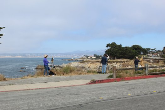
I loved how free the people are in Monterey, This must be a popular painting location
The road to San Francisco
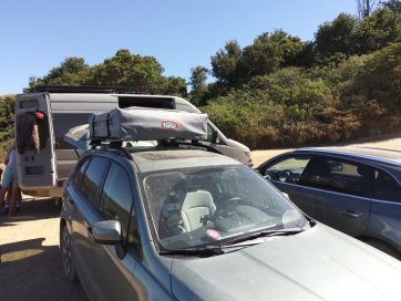
I departed Monterey the next day to make a short drive north of Santa Cruz. I passed through Soquel, the town where Tepui (maker of my roof top tent) is located. I thought I should stop by to try and get a sponsorship deal from them. I have had so many people ask me about the RTT and I’ve been an unofficial salesman on multiple occasions.
Passing through Santa Cruz, I saw the highest concentration of windsurfing/kitesurfing I have ever seen. People park along Route 1, hike down to the beach, and let the wind tour them around the ocean. I’ll need a lesson first. The wind is pretty intense around Santa Cruz so the conditions are ideal for [windsports].
After passing by seemingly hundreds of windsurfers, I wound up stopping for the night off of Route 1 next to Davenport Bluffs. Another free but scenic spot by the ocean. There are signs everywhere cautioning people to stay back. The cliffs are very high (up to 200 feet in some places) and I’m sure people fall off occasionally. The only issue with my spot for the night was the cement plant located directly across the street that let off a few high-pressure release sounds in the middle of the night. Other than that, I was okay boondocking for the night to wake up to a great cliffside view of the ocean.

I’m continuing north up the California coast as I hope to see more and more redwoods, mountains, and maybe some more otters. I’m chilling in San Francisco now as I needed a break from moving to a new place almost everyday. Plus, if I ever needed a stable connection, it would be around Silicon Valley. Thanks for reading and check back soon.
Loved this post! This is the one section of the CA coast that I have not driven. It looks so beautiful I will have to go back and do this. I love that you have camped it and I would love to see the RTT one day.
It’s awesome! I wish I could have spent more time there. I can let you in on the “secret” camp spots. I’m making a review video for the tent but I’ll show you in person soon hopefully.